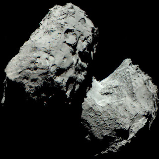
For using irregular bodies in typical GIS mapping applications -- the current situation is not good. Without playing tricks, I would currently have to recommend using a specialize true 3D GIS-like application (see a couple listed below).
So deriving the body shape is currently fairly well understood (Nefian - presentation, paper, Machtoub - paper). This can be done with lidar and/or stereo, slope, or gravity (some older references).
But for GIS, the issue is that most mapping applications are not well suited for working with irregular shapes (what we call true 3D. We call raster DEMs/TINs only 2.5D). Now there are some GIS-like initiatives from our colleagues at APL (small body mapping tool), JAXA, JPL (vestatrek) and ASU's (JMars).
So what to do if you still wish to use a more typical 2.5D GIS application...
2.) So for "peanuts", there has been research to take these irregular bodies and unwrap it for mapping applications. This generally means warping the irregular body into one Cartesian system (see: Stooke, Morphographic). As a graphic example, I like this video for unwrapping a face for a 3D texture in Blender - although sort-of creepy (see 10.5 minutes into the video).
3.) Others are testing methods to split up the body into multiple map projections. How to best split up the body would still be difficult and may require several different map projections to minimize large distortions for each part of the body. I think this might be explained for comet 67P by F. Preusker et al. but the paper is locked down. This seems the most reasonable solution since one can use well known map projection equations and applications will be able to still run stats (accurate measures) on the different parts. But displaying all the part together might be a challenge since they would essentially be defined as independent bodies.
But for GIS, the issue is that most mapping applications are not well suited for working with irregular shapes (what we call true 3D. We call raster DEMs/TINs only 2.5D). Now there are some GIS-like initiatives from our colleagues at APL (small body mapping tool), JAXA, JPL (vestatrek) and ASU's (JMars).
So what to do if you still wish to use a more typical 2.5D GIS application...
1.) For bodies that are not crazy differently from an ellipse/triaxial shape, the easiest method would be to use a best fit sphere. This is essentially what the IAU recommends for most odd bodies. Now for peanuts (or dumbbell) shaped bodies, this won't work too well (e.g. comet 67P/Churyumov-Gerasimenko or images from Rosetta).
3.) Others are testing methods to split up the body into multiple map projections. How to best split up the body would still be difficult and may require several different map projections to minimize large distortions for each part of the body. I think this might be explained for comet 67P by F. Preusker et al. but the paper is locked down. This seems the most reasonable solution since one can use well known map projection equations and applications will be able to still run stats (accurate measures) on the different parts. But displaying all the part together might be a challenge since they would essentially be defined as independent bodies.
I would love to hear other ideas for this topic.
-Trent

No comments:
Post a Comment